


As Rhode Island has been experiencing a changing climate, the University of Rhode Island’s Coastal Resources Center/Sea Grant and its partners like URI’s Ocean Engineering and Environmental Data Center, the Coastal Resources Management Council, among others have been active in developing a suite of user-friendly tools to help you assess the risks, and identify options to reduce future impacts from flooding, sea level rise, and coastal erosion.
These Resilience Tools are aids for understanding risk to coastal hazards and identifying opportunities. For example, they can help residents concerned about properties or decision-makers looking to protect community infrastructure. By understanding risk, communities can be better prepared to adapt, and plan for a stronger and safer future.
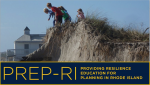 Where can I learn about planning for climate change impacts? PREP-RI Modules, or “Providing Resilience Education for Planning in Rhode Island,” provides brief educational voice-over PowerPoints and local resources to assist communities in planning for climate change in Rhode Island.
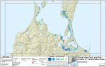
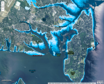 How much will a property flood? STORMTOOLS is an interactive mapper and RIGIS database illustrating both the extent and depth of flooding from various storm surge and sea level rise scenarios. Users can access current and future flooding projections.
 Is a property in the FEMA flood zone? Rhode Island Floodplain Mapping Tool, as well as the FEMA (Federal Emergency Management Agency) Flood Map Service Center, show flood hazard areas as delineated by FEMA on Flood Insurance Rate Maps that include Base Flood Elevation.
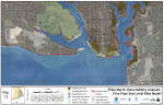
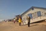 Can I assess multiple impacts to a coastal property? Rapid PACE, or “Rapid Property Assessment and Coastal Exposure,” provides municipal officials a summary of the potential impacts of storm scenarios and the effects of marsh migration and erosion while incorporating sea level rise projections.
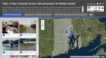 How can coastal green infrastructure enhance resilience? Tour of Green Infrastructure is a Story Map showing several locations throughout Rhode Island that have successfully used green infrastructure techniques to reduce local stormwater issues and enhance habitat value.
Green Infrastructure Fact Sheet
 How will my community be impacted? Community Vulnerability outlines projects by State agencies regarding climate impacts in coastal communities. Information is available for transportation assets, public water utilities, and sewage treatment facilities, as well as socioeconomic impacts.
 How will coastal wetlands be impacted by sea level rise? SLAMM, or “Sea Level Affecting Marshes Model” maps, show how coastal wetlands will likely drown in place, or migrate onto adjacent upland areas under projected sea level rise scenarios.
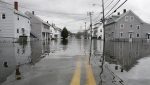
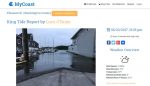 Where can I see real time photos of local coastal flooding? MyCoast, a crowd-sourced website (and mobile app), hosts photographs uploaded by Rhode Islanders showing local coastal flooding from extreme tides (or King Tides) and storms.