Public Workshop: Protecting Newport Historic and Cultural Assets from Flooding Caused by Sea Level Rise

Associated Press Jim Davis kayaks through waters flooding Bowen’s Wharf in October 2012 after Superstorm Sandy in historic Newport, R.I

Event kicks off community-based historic preservation effort to address coastal climate change impacts on Newport’s historic properties

The public is invited to participate in a community workshop on flood protection for historic and culturally valuable properties on Newport’s coast. The workshop is scheduled for THURSDAY, JULY 14, 2016, 3-7 P.M., at Emmanuel Church, 42 Dearborn St., Newport, RI 02840.

NOTE: The public is welcome for the whole event; a general overview of the project will be given at 5 p.m. to ensure attendees arriving later in the day have ample opportunity to gain information. RSVP if attending by July 11 to ensure adequate refreshments.

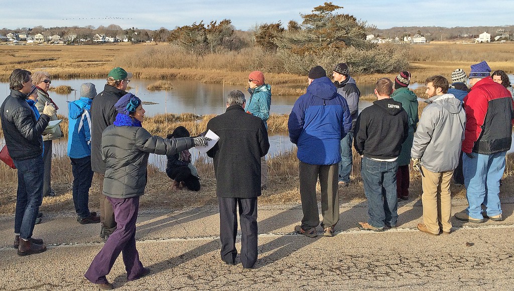
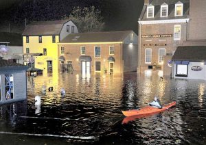
The workshop follows the April 2016 Keeping History Above Water Conference in Newport, which explored historic preservation efforts regarding flooding from sea level rise a key impact of climate change. Newport hosts a broad array of historical and cultural assets, including registered historic buildings, and rising water and increased storminess is expected to threaten these over time. The University of Rhode Island (URI) Coastal Resources Center (CRC) and Rhode Island Sea Grant are facilitating the meeting for several community groups interested in continuing the conference dialogue. The event is also possible due to generous support from the Prince Charitable Trusts.

Science indicates that Rhode Island is more likely than many other coastal states to experience flooding over time from sea level rise, said Dawn Kotowicz, a coastal manager for CRC and extension agent for Rhode Island Sea Grant. Coastal development, including the historic properties and cultural assets that Newport values, is at risk, so collaborating on practical solutions is critical.

CRC and Rhode Island Sea Grant, at the URI Graduate School of Oceanography, provide Rhode Island and beyond with a variety of community-based coastal management and outreach services and programs.

For more information about the workshop, please contact Dawn Kotowicz at (401) 874-6152. Please RSVP. For media inquiries, contact Sue Kennedy at (401) 874-6107 or skennedy@crc.uri.edu.

CRC Working to Help Save Historic Structures from Rising Tides

Read the latest on how CRC’s coastal team has participated in the effort to save historic structures in Newport from flood water and sea level rise. Dawn Kotowicz, Teresa Crean and Pam Rubinoff have been working with the Newport Restoration Foundation, and the team will participate in the History Above Water conference in April.

New Maps Are a Key Tool For Saving State’s Wetlands from Flooding

Coastal wetlands protect communities from floods, an impact of storms and sea level rise related to climate change, and Rhode Island has a new tool to help prioritize projects for protecting or restoring these habitats. Newly adopted SLAMM (Sea Levels Affecting Marshes Model) maps developed by CRC and Rhode Island Sea Grant with the Rhode Island Coastal Resources Management Council (CRMC) show which wetlands are most threatened. The maps are available for all 21 Rhode Island coastal communities.

To learn more about SLAMM visit the CRMC website, which has a complete library of the maps or see the related article on EcoRI News.

CRC Leads EPA on Tour of Climate Change Front Lines

wetlandswalk2
Touring salt marshes in Westerly, R.I. (CRC photo)

The U.S. Environmental Protection Agency’s New England Region Administrator Curt Spaulding and several of his colleagues spent two days this week touring Rhode Island to see the firsthand effects of climate change and sea level rise and to learn what municipalities, the state, URI and local organizations are doing about them. CRC and Rhode Island Sea Grant, who have collaborated with partners to address these issues, hosted the tour.

epaguy
Grover Fugate, executive director of the Rhode Island Coastal Resources Management Council, left, speaks with Curt Spaulding, administrator of the federal EPA’s New England Region. (CRC photo)

Spaulding and his colleagues saw vivid impacts of increasingly frequent and intense storms Thursday when touring the Misquamicut section of Westerly, which was hit hard by Superstorm Sandy in 2012. Since then some shoreline homes have been elevated or moved, and some businesses have chosen to scale back.

CRC and its partners were able to share how the state’s tools for taming the impacts of climate change can be applied in other New England locations, such as improving coastal management policy and planning tools to better address flooding and erosion from climate change and seal level rise. Examples include the Sea Level Affecting Marshes Model (SLAMM) for predicting changes in coastal wetlands and StormTools, which gives users interactive, detailed maps that illustrate sea level rise and storm surge flooding scenarios.

News reports on the visit were featured on Rhode Island Public Radio and in The Providence Journal.