URI-logo
GSO-logo
CRC-logo
Coastal Resources Center
Home | Contact
  • About
    • The Challenge
    • CRC Vision and Approach
    • CRC Values and History
    • Partners
    • Staff
    • Contact Us
  • Topic Areas
    • Fisheries and Aquaculture
    • Climate Change
    • Community Planning
    • Marine Conservation
    • Capacity Development
    • Coastal and Ocean Planning
  • Projects and Activities
  • Locations
    • Global
    • Africa
    • Asia Pacific
    • Latin America & Caribbean
    • United States
    • Rhode Island
  • Publications

Blog Archives

How Will Businesses Stay Afloat With Rising Seas?

Downtown Wickford, RI is at risk to storm surge and sea-level rise.

Giving Business an Adaptation Boost: With the threat of stronger storms
and sea level rise, a key concern is making sure business — one sector
of coastal communities — keeps its head above water. CRC continues its
efforts to provide targeted technical assistance to the private sector
statewide, educating them about chief climate change threats, and
building their confidence to work with tools enabling them to step
forward on their own in protecting people and assets. A domestic
project, “Risk Reduction for Small Business Resiliency,” is supporting a
CRC team effort, with Pam Rubinoff as the lead, to develop a series of
industry focused manuals — marinas are an example of the kinds of
businesses represented — that will provide companies with step-by-step
guidance for preparing game plans that make them able to withstand the
flooding and other threats posed by storms and strong sea level rise.
The project is led by RPS, a global planning corporation, which holds
that the guides and “our approach will allow small businesses to emerge
as leaders in climate preparedness by maximizing opportunities and
minimizing risks.” Through other programs supported in the CRC
portfolio, Pam and the “CR,” or Coastal Resiliency, team also spent the
fall stocking the resiliency toolbox — an expanded PREP RI (Providing
Resilience Education for Planning Preparedness in Rhode Island)
initiative, for example, as well as the completed Rhode Island Shoreline
Change Special Area Management Plan (Beach SAMP) documents — so
businesses as well as public and community sectors can continue their
adaptation efforts.

Flooding estimate for downtown Wickford. See STORMTOOLS.

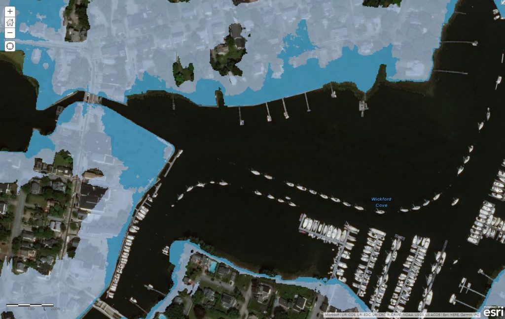
The STORMTOOLS map above shows flooding zones in downtown Wickford, RI — the white represents 3 ft. of sea level rise, while the turquoise is 7 ft of rise.  The photo at the top of the story was taken at the intersection in the NW corner of the map..


Archives

  • February 2019
  • November 2018
  • October 2018
  • September 2018
  • April 2018
  • March 2018
  • February 2018
  • January 2018
  • December 2017
  • November 2017
  • September 2017
  • January 2017
  • November 2016
  • October 2016
  • September 2016
  • August 2016
  • July 2016
  • June 2016
  • May 2016
  • April 2016
  • March 2016
  • February 2016
  • January 2016
  • December 2015
  • September 2015
  • August 2015
  • July 2015
  • June 2015
  • May 2015
  • April 2015
  • March 2015
  • February 2015
  • January 2015
  • December 2014
  • November 2014
  • October 2014
  • September 2014
  • August 2014
  • July 2014
  • June 2014
  • March 2014
  • February 2014
  • January 2014
  • December 2013
  • November 2013
  • October 2013
  • September 2013
  • July 2013
  • June 2013
  • May 2013
  • February 2013
  • December 2012

Meta

  • Log in
CRC-logo
COASTAL RESOURCES CENTER
220 South Ferry Road, Narragansett RI 02882
P (401) 874-6224
E info@crc.uri.edu
THE
UNIVERSITY OF
RHODE ISLAND

Graduate School of
Oceanography
© Copyright 2025 University of Rhode Island.
The University of Rhode Island is an equal opportunity employer committed
to community, equity, and diversity and to the principles of affirmative action.